LiDAR (Light Detection and Ranging) technology is transforming urban planning by providing detailed, three-dimensional data that enhances the design, management, and development of smart cities and infrastructure. By offering precise information about urban environments, LiDAR supports more efficient planning, better decision-making, and improved infrastructure management. This article explores how LiDAR is being used in urban planning and the benefits it brings to creating smart cities and managing urban infrastructure.
Mapping and Analyzing Urban Environments
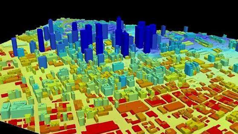
LiDAR technology is highly effective for mapping and analyzing complex urban environments. Traditional mapping methods can be limited in terms of accuracy and detail, especially in densely built areas. LiDAR provides high-resolution, three-dimensional data that captures the intricate details of urban landscapes, including buildings, roads, and vegetation.
LiDAR data is used to create detailed digital elevation models (DEMs) and 3D city models, which are essential for understanding the spatial arrangement of urban features. For example, LiDAR can accurately map the height of buildings, the layout of streets, and the distribution of green spaces. This information is valuable for urban planners, architects, and engineers involved in designing and managing urban areas.
Supporting Infrastructure Design and Maintenance
Infrastructure design and maintenance are critical aspects of urban planning, and LiDAR technology supports these processes by providing precise data on existing conditions and planning requirements.
LiDAR data can be used to assess the condition of infrastructure, such as roads, bridges, and utilities. For example, detailed LiDAR surveys can identify changes in road surfaces, detect structural damage in bridges, and monitor the condition of utility networks. This information helps in planning maintenance activities, prioritizing repairs, and ensuring the safety and functionality of infrastructure.
Enhancing Transportation Planning and Management
Transportation planning and management benefit significantly from LiDAR technology, which provides detailed data on road networks, traffic patterns, and pedestrian infrastructure.
LiDAR data can be used to analyze traffic flow, identify congestion points, and plan improvements to transportation systems. For example, LiDAR surveys can create detailed maps of road intersections, pedestrian crossings, and bike lanes, which are essential for designing efficient and safe transportation networks. Additionally, LiDAR data supports the planning of public transportation systems, including bus routes and transit stations.
Supporting Smart City Development
Smart cities rely on advanced technologies and data to improve urban living and enhance sustainability. LiDAR technology plays a key role in smart city development by providing detailed information that supports various smart city applications.
For example, LiDAR data can be used to monitor and manage urban infrastructure, support energy-efficient building design, and improve environmental monitoring. LiDAR can also assist in the development of smart utilities, such as water and waste management systems, by providing accurate data on infrastructure and service areas.
Improving Environmental and Green Space Planning
Urban environments require careful planning of green spaces and environmental features to ensure livability and sustainability. LiDAR technology supports this by providing detailed data on vegetation, land use, and environmental conditions.
LiDAR data can be used to map and analyze urban forests, parks, and green roofs, supporting the planning and management of green spaces. For example, LiDAR surveys can assess the density and health of vegetation, monitor changes in land cover, and support the design of sustainable urban landscapes. This information helps in creating healthier and more enjoyable urban environments.
Enhancing Emergency Response and Disaster Management
LiDAR technology enhances emergency response and disaster management by providing detailed data on urban areas and infrastructure. This information is valuable for planning and executing emergency response strategies.
LiDAR data can be used to create accurate maps of urban areas, including building heights, street layouts, and critical infrastructure. This information helps emergency responders navigate disaster zones, assess damage, and plan recovery efforts. For example, LiDAR surveys can provide detailed information on the impact of natural disasters such as floods or earthquakes, supporting more effective response and recovery operations.
Supporting Urban Research and Policy Making
Urban research and policy making benefit from LiDAR technology by providing detailed and accurate data on urban environments. This information supports evidence-based decision-making and the development of effective urban policies.
LiDAR data can be used to analyze trends in urban growth, assess the impact of land use policies, and support research on urban sustainability. For example, LiDAR surveys can provide data on changes in land cover, population density, and infrastructure development, helping policymakers understand the implications of their decisions and plan for future growth.
Future Trends and Innovations
The future of LiDAR in urban planning is promising, with ongoing advancements driving new applications and capabilities. Innovations include the development of more advanced LiDAR sensors, integration with other technologies such as GIS (Geographic Information Systems) and AI (Artificial Intelligence), and improvements in data processing and analysis.
For example, the integration of LiDAR with GIS allows for more detailed and comprehensive analysis of urban environments. Advances in AI and machine learning will enhance the ability to interpret LiDAR data and provide actionable insights for urban planning and management.
Conclusion
LiDAR technology has transformed urban planning by providing detailed, high-resolution data that supports the design, management, and development of smart cities and infrastructure. From mapping urban environments and supporting infrastructure design to enhancing transportation planning and improving environmental management, LiDAR offers significant benefits for modern urban planning. As technology continues to evolve, LiDAR will play an increasingly important role in shaping smart cities and managing urban environments more effectively.


