LiDAR (Light Detection and Ranging) has revolutionized archaeology by providing unprecedented insights into ancient civilizations and their environments. By using laser pulses to create detailed 3D maps of landscapes, LiDAR helps archaeologists discover hidden structures, understand ancient land use, and preserve cultural heritage. This article explores how LiDAR is transforming archaeological research and uncovering the secrets of the past.
Discovering Hidden Sites
One of the most significant contributions of LiDAR to archaeology is its ability to reveal hidden structures and sites that are not visible on the ground. Traditional excavation methods often rely on surface surveys or small test trenches, which can be limited by vegetation, soil cover, or modern development. LiDAR, however, penetrates through trees and undergrowth to map the ground surface with high precision.
For example, LiDAR has been instrumental in uncovering previously unknown ancient cities and structures. In the dense jungles of Central America, LiDAR scans have revealed the remains of complex urban networks and monumental buildings that were hidden beneath thick vegetation. The discovery of the ancient Maya city of Caracol in Belize and the extensive archaeological site of Angkor in Cambodia are notable examples where LiDAR played a key role in revealing the scale and layout of these lost civilizations.
Mapping Ancient Landscapes
LiDAR provides archaeologists with detailed topographic maps that help them understand how ancient cultures interacted with their environment. By mapping the landscape, researchers can analyze ancient agricultural practices, water management systems, and settlement patterns.
For instance, LiDAR data has been used to study ancient irrigation systems and agricultural terraces, providing insights into how civilizations adapted to and managed their natural resources. In places like the Andes, LiDAR has uncovered extensive networks of terraces and canals used by the Inca Empire, revealing the complexity of their agricultural techniques and land use.
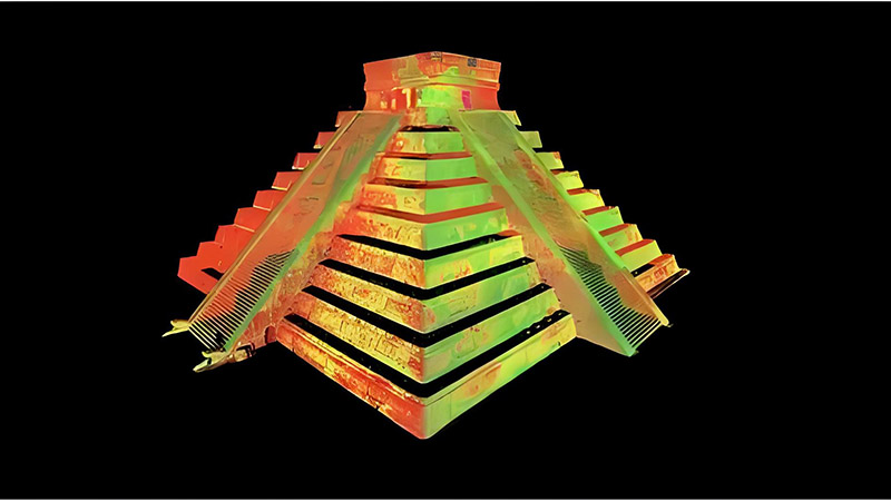
Enhancing Site Preservation
LiDAR is not only useful for discovering and mapping archaeological sites but also for preserving them. Detailed 3D models created from LiDAR data can be used to monitor the condition of sites and assess the impact of environmental factors or human activities. This information is critical for developing conservation strategies and protecting cultural heritage from degradation or destruction.
For example, LiDAR has been employed to monitor the stability of ancient structures, such as temples and pyramids, by detecting shifts or changes in their condition over time. This data helps conservationists implement appropriate measures to safeguard these historical sites for future generations.
Revealing Settlement Patterns
LiDAR allows archaeologists to analyze settlement patterns and urban planning in ancient civilizations. By examining the spatial distribution of structures and features, researchers can gain insights into social organization, trade networks, and cultural practices.
For example, LiDAR data has been used to study the layout of ancient cities, such as the Roman city of Pompeii, and to analyze the arrangement of residential, public, and industrial areas. This information helps researchers understand how ancient societies were organized and how they adapted to their environments.
Investigating Burial Sites and Rituals
LiDAR can also reveal burial sites and ritualistic features that are otherwise difficult to detect. By mapping the subtle variations in the terrain, LiDAR can uncover ancient burial mounds, ceremonial structures, and other features associated with burial practices and rituals.
For example, LiDAR has been used to locate ancient burial sites in regions like the British Isles, where large, circular earthworks known as henges and barrows are common. These discoveries provide valuable information about ancient burial customs and the significance of these sites in past cultures.
Future Prospects in Archaeology
As LiDAR technology continues to advance, its applications in archaeology are expanding. Future developments include higher-resolution sensors, improved data processing techniques, and integration with other technologies such as drones and Geographic Information Systems (GIS). These advancements will enhance the ability to discover and analyze archaeological sites, making it possible to explore even the most challenging environments.
For example, advancements in LiDAR technology may enable the detection of even finer details and more subtle features in the landscape, leading to new discoveries and a deeper understanding of ancient civilizations.
Conclusion
LiDAR has become an invaluable tool in archaeology, offering new perspectives on ancient civilizations and their environments. By revealing hidden structures, mapping landscapes, and enhancing site preservation, LiDAR is transforming the way archaeologists conduct research and preserve cultural heritage. As technology continues to evolve, LiDAR will play an increasingly important role in uncovering the secrets of the past and advancing our understanding of human history.


