LiDAR technology has transformed the construction and infrastructure industries by offering unparalleled precision and efficiency in data collection and analysis. By generating high-resolution, 3D maps of construction sites and infrastructure projects, LiDAR enables engineers, architects, and project managers to plan, execute, and manage projects with greater accuracy. This article explores how LiDAR is enhancing the construction and infrastructure sectors, from planning and design to maintenance and safety.
Planning and Design
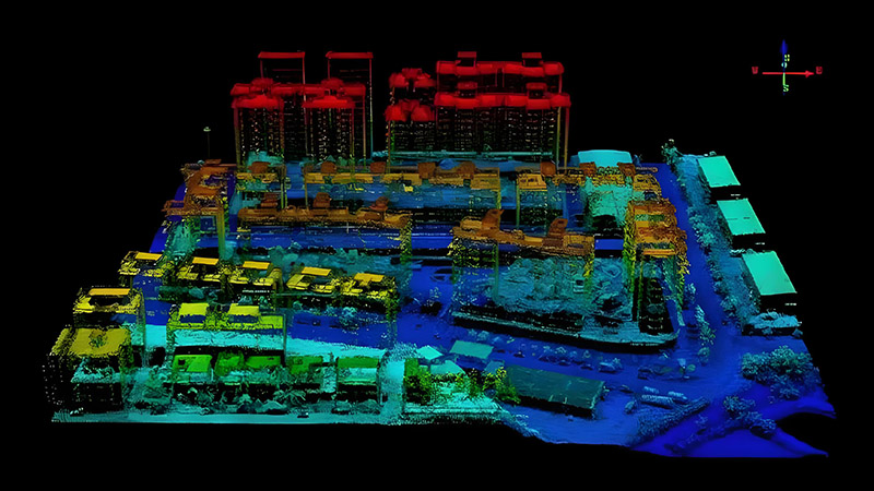
In the planning and design phases of construction, LiDAR provides detailed and accurate topographic data that is essential for creating precise models and blueprints. Traditional surveying methods can be time-consuming and prone to errors, but LiDAR offers a faster and more reliable alternative. By using aerial LiDAR scanners or terrestrial laser scanners, surveyors can quickly capture the geometry of a site, including buildings, terrain, and existing infrastructure.
This data allows architects and engineers to visualize the project in 3D, identify potential challenges, and make informed design decisions. For example, LiDAR data can reveal hidden underground utilities or assess the impact of a new construction on existing structures, helping to avoid costly design errors and delays.
Construction Monitoring and Quality Control
During construction, LiDAR is used to monitor progress and ensure that work is being carried out according to design specifications. High-resolution LiDAR scans provide detailed snapshots of the construction site at various stages, allowing project managers to compare actual conditions with the planned design.
This capability is crucial for quality control, as it helps identify discrepancies between the design and the constructed elements. For example, if the placement of a building’s foundation is slightly off, LiDAR can detect this deviation and prompt corrective actions before it becomes a significant issue. Regular LiDAR scans also help track progress and ensure that the project stays on schedule.
Infrastructure Inspection and Maintenance
LiDAR is an invaluable tool for inspecting and maintaining infrastructure. Bridges, roads, and other critical infrastructure components require regular inspections to ensure safety and functionality. Traditional inspection methods can be labor-intensive and sometimes hazardous, but LiDAR offers a safer and more efficient alternative.
For instance, LiDAR can be used to assess the condition of bridge decks, detect structural issues such as cracks or deformations, and measure the wear and tear on road surfaces. By creating detailed 3D models of infrastructure, LiDAR helps engineers and maintenance teams identify problem areas and plan repairs more effectively.
Asset Management and Documentation
In addition to its role in construction and maintenance, LiDAR is used for asset management and documentation. Detailed 3D models generated by LiDAR scans serve as accurate records of infrastructure assets, which are valuable for future reference and management. These models can be used to track changes over time, plan upgrades or expansions, and manage maintenance schedules.
For example, city planners and facility managers can use LiDAR data to create comprehensive inventories of public assets, such as streetlights, benches, and signage. This information helps optimize resource allocation and improve urban management.
Safety and Risk Management
Safety is a top priority in construction and infrastructure projects, and LiDAR contributes significantly to risk management. By providing detailed and accurate data on site conditions, LiDAR helps identify potential hazards and assess risks before they become critical issues. For example, LiDAR can detect unstable soil conditions or structural weaknesses that may pose risks to workers or the public.
LiDAR’s ability to create 3D models of construction sites also facilitates safety planning and emergency response. In the event of an accident or natural disaster, LiDAR data can be used to assess damage, plan rescue operations, and coordinate recovery efforts.
Future Trends and Innovations
The future of LiDAR in construction and infrastructure is promising, with ongoing advancements in technology driving new applications and improvements. Innovations such as smaller, more affordable LiDAR sensors and integration with other technologies like drones and robotics are expanding the possibilities for LiDAR use in these industries.
For instance, drone-based LiDAR systems offer the ability to capture data from hard-to-reach areas or large-scale sites, providing a cost-effective solution for surveying and monitoring. Additionally, the development of real-time LiDAR systems will enhance the ability to monitor construction progress and make immediate adjustments as needed.
Conclusion
LiDAR technology is revolutionizing the construction and infrastructure industries by providing precise, high-resolution data that enhances planning, execution, and maintenance. From improving design accuracy and construction quality to enabling efficient asset management and safety measures, LiDAR offers significant benefits for project management and risk mitigation. As technology continues to advance, LiDAR will play an even greater role in shaping the future of construction and infrastructure development.


