LiDAR (Light Detection and Ranging) has significantly impacted the mining industry by enhancing resource extraction processes, improving safety, and optimizing operational efficiency. By providing detailed 3D mapping and accurate measurements, LiDAR technology helps mining companies make informed decisions, manage resources effectively, and reduce environmental and safety risks. This article explores how LiDAR is revolutionizing the mining industry and what benefits it brings to resource extraction and site management.
Accurate Resource Mapping and Exploration
One of the primary applications of LiDAR in mining is in resource mapping and exploration. Before mining operations commence, it is crucial to have an accurate understanding of the terrain and geological features. LiDAR provides high-resolution, 3D maps of the surface and subsurface, allowing geologists and engineers to identify potential mineral deposits and assess the feasibility of mining projects.
LiDAR data helps in creating detailed topographic maps that reveal geological formations, fault lines, and other features that influence resource distribution. This information is essential for determining where to drill and extract resources, reducing the risk of costly exploration errors.
Enhancing Mine Planning and Design
Effective mine planning and design are critical for optimizing resource extraction and minimizing environmental impact. LiDAR plays a key role in this process by providing precise measurements of the terrain and existing infrastructure. This data enables engineers to design mining operations with a clear understanding of the site’s topography and geological conditions.
For example, LiDAR data can be used to design open-pit mines, underground tunnels, and waste management facilities. By accurately mapping the terrain, engineers can plan the most efficient routes for transportation and material handling, ensuring that resources are extracted in a cost-effective and environmentally responsible manner.
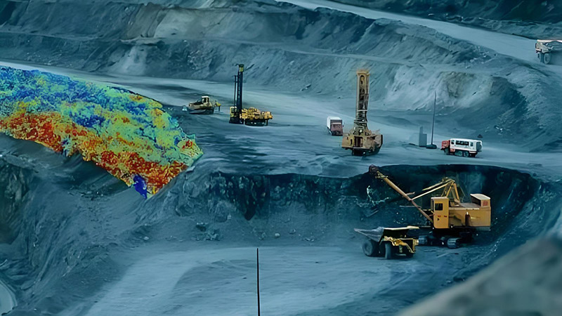
Monitoring and Managing Operations
LiDAR is instrumental in monitoring and managing mining operations. Regular LiDAR scans provide up-to-date information on site conditions, including changes in the terrain, stability of slopes, and volume of extracted materials. This real-time data helps mine operators make informed decisions and respond quickly to any issues that arise.
For instance, LiDAR can be used to monitor the stability of pit walls and waste dumps, detecting potential landslides or erosion before they pose significant risks. By identifying these hazards early, mining companies can implement corrective measures to ensure the safety of workers and equipment.
Improving Safety and Risk Management
Safety is a top priority in mining operations, and LiDAR contributes significantly to risk management. LiDAR technology helps identify potential hazards, such as unstable ground or underground voids, by providing detailed 3D models of the mining site. This information is crucial for assessing and mitigating risks associated with mining activities.
For example, LiDAR can be used to create detailed slope stability models, allowing engineers to evaluate the risk of landslides and design appropriate support structures. Additionally, LiDAR data helps in planning safe access routes and ensuring that mining operations do not encroach on areas prone to subsidence or other safety issues.
Environmental Monitoring and Compliance
LiDAR is also valuable for environmental monitoring and ensuring compliance with regulatory requirements. Mining operations can have significant environmental impacts, including changes in land use, water quality, and habitat disruption. LiDAR provides accurate data for assessing these impacts and implementing mitigation measures.
For example, LiDAR can be used to monitor changes in land cover and vegetation, assess the impact of mining on nearby water bodies, and track the effectiveness of reclamation efforts. By providing detailed information on environmental conditions, LiDAR helps mining companies comply with environmental regulations and reduce their ecological footprint.
Future Trends and Innovations
The future of LiDAR in mining is promising, with ongoing advancements in technology driving new applications and improvements. Emerging trends include the development of more compact and affordable LiDAR sensors, integration with drones and autonomous vehicles, and advancements in data processing and analysis.
For example, drone-based LiDAR systems offer the ability to capture data from hard-to-reach areas and large-scale mining sites, providing a cost-effective solution for surveying and monitoring. Additionally, the integration of LiDAR with real-time data analytics and machine learning will enhance the ability to predict and manage mining operations more effectively.
Conclusion
LiDAR technology has transformed the mining industry by providing accurate, high-resolution data that enhances resource mapping, mine planning, and operational management. From improving safety and risk management to monitoring environmental impacts, LiDAR offers significant benefits for optimizing resource extraction and minimizing environmental and safety risks. As technology continues to advance, LiDAR will play an increasingly important role in shaping the future of mining and ensuring sustainable resource management.


