LiDAR (Light Detection and Ranging) technology has revolutionized archaeology by providing high-resolution, three-dimensional data that uncovers hidden structures, maps ancient landscapes, and aids in the preservation of heritage sites. By penetrating vegetation and capturing detailed topographic information, LiDAR enables archaeologists to explore and study ancient civilizations and archaeological sites with unprecedented clarity. This article explores how LiDAR is transforming archaeology and the benefits it brings to uncovering and preserving our historical heritage.
Revealing Hidden Archaeological Features
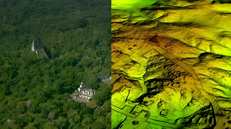
One of the most significant applications of LiDAR in archaeology is revealing hidden features that are not visible on the ground. Traditional excavation methods can be limited by vegetation, soil cover, or challenging terrain, but LiDAR technology provides a detailed view of the landscape that can uncover previously unknown structures.
LiDAR works by emitting laser pulses from an aircraft or drone and measuring the time it takes for the pulses to return after bouncing off the ground. This data is used to create high-resolution, 3D topographic maps that reveal subtle variations in the landscape. For example, LiDAR has been used to discover ancient Mayan cities hidden beneath dense tropical forests and uncover buried structures in archaeological sites around the world.
Mapping Ancient Landscapes
LiDAR technology is instrumental in mapping ancient landscapes and understanding the spatial organization of past civilizations. By providing detailed topographic data, LiDAR helps archaeologists reconstruct the layout of ancient cities, road networks, and agricultural systems.
For example, LiDAR data has been used to map the intricate network of canals and fields used by ancient civilizations such as the Maya and the Ancestral Puebloans. This information helps researchers understand how these societies adapted to their environments, managed resources, and organized their communities.
Enhancing Site Documentation and Preservation
Documentation and preservation are critical aspects of archaeological research, and LiDAR technology enhances these processes by providing accurate and detailed records of archaeological sites. High-resolution LiDAR data allows for precise mapping of site features, which is essential for documenting their condition and planning conservation efforts.
LiDAR can also be used to create 3D models of archaeological sites, which serve as valuable records for future research and education. These models can be used to monitor changes over time, assess the impact of environmental factors, and develop strategies for preserving and protecting heritage sites.
Supporting Non-Invasive Exploration
LiDAR technology supports non-invasive exploration methods that minimize the impact on archaeological sites. Traditional excavation can be disruptive and destructive, but LiDAR provides a way to explore and study sites without disturbing the ground.
By using LiDAR to survey large areas, archaeologists can identify potential excavation sites and prioritize areas for further investigation. This approach allows for more targeted and efficient excavation, reducing the risk of damage to valuable archaeological remains.
Discovering New Sites and Expanding Knowledge
LiDAR has been instrumental in discovering new archaeological sites and expanding our knowledge of ancient civilizations. By analyzing LiDAR data, researchers can identify patterns and anomalies in the landscape that suggest the presence of undiscovered sites.
For example, LiDAR surveys have led to the discovery of previously unknown settlements, burial mounds, and ceremonial structures. These findings contribute to our understanding of ancient cultures, trade networks, and societal organization.
Improving Archaeological Research and Analysis
LiDAR technology enhances archaeological research and analysis by providing detailed and accurate data that supports a range of analytical methods. The high-resolution topographic maps created by LiDAR allow researchers to conduct spatial analysis, assess site layout, and investigate the relationship between different features.
LiDAR data can be integrated with other remote sensing technologies, such as satellite imagery and ground-penetrating radar, to provide a comprehensive view of archaeological sites. This integration improves the accuracy and depth of research, leading to new insights and discoveries.
Future Trends and Innovations
The future of LiDAR in archaeology is promising, with ongoing advancements driving new applications and capabilities. Innovations include the development of more advanced LiDAR sensors, integration with emerging technologies such as artificial intelligence and machine learning, and improvements in data processing and analysis.
For example, the use of drone-based LiDAR systems allows for more flexible and cost-effective surveys of archaeological sites. Integration with AI algorithms will enhance the ability to analyze and interpret LiDAR data, providing deeper insights into ancient civilizations and their environments.
Conclusion
LiDAR technology has transformed archaeology by providing detailed, high-resolution data that uncovers hidden structures, maps ancient landscapes, and supports the preservation of heritage sites. From revealing new archaeological features and expanding knowledge of ancient civilizations to enhancing site documentation and non-invasive exploration, LiDAR offers significant benefits for archaeological research and conservation. As technology continues to evolve, LiDAR will play an increasingly important role in uncovering and protecting our historical heritage.


