LiDAR (Light Detection and Ranging) technology has revolutionized many fields, including cave and karst mapping. By providing high-resolution, three-dimensional data, LiDAR offers new possibilities for exploring and documenting subterranean and karst environments. This article explores the role of LiDAR in cave and karst mapping, highlighting its advantages, applications, and potential future developments.
How LiDAR Works
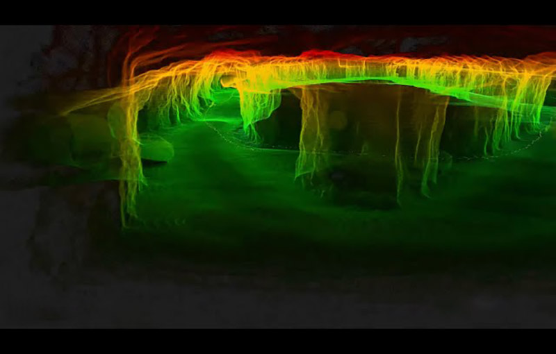
LiDAR technology operates by emitting laser pulses and measuring the time it takes for the light to reflect back to the sensor. These measurements are used to create a detailed 3D point cloud that represents the surface and features of the scanned area. In cave and karst mapping, LiDAR provides a precise and comprehensive view of subterranean landscapes, capturing details that might be missed with traditional methods.
Applications in Cave Mapping
LiDAR has significantly enhanced cave mapping by offering a non-invasive and efficient way to create detailed 3D models of cave systems. The high-resolution data provided by LiDAR enables the accurate representation of cave passages, chambers, and geological features. This technology is particularly useful for mapping complex cave systems with intricate formations and extensive networks.
One notable application of LiDAR in cave mapping is the creation of detailed digital models that can be used for scientific research, conservation, and exploration. These models allow researchers to study the cave’s structure and dynamics, monitor changes over time, and assess the impact of human activity. Additionally, LiDAR-generated models provide valuable information for cave conservation efforts, helping to identify and protect sensitive areas.
Applications in Karst Mapping
In karst mapping, LiDAR offers similar benefits by providing detailed topographic data that reveals surface and subsurface karst features. LiDAR is particularly useful for mapping large karst areas and identifying features such as sinkholes, dolines, and underground rivers.
LiDAR data can be used to create accurate 3D models of karst landscapes, helping geologists and environmental scientists understand the spatial relationships between different features. This information is essential for assessing groundwater resources, managing land use, and mitigating hazards associated with karst terrain.
Advantages of LiDAR
The use of LiDAR in cave and karst mapping offers several advantages over traditional methods. One of the primary benefits is the ability to capture high-resolution, three-dimensional data quickly and efficiently. LiDAR technology allows for detailed mapping of complex environments, reducing the need for extensive fieldwork and manual measurements.
Additionally, LiDAR data can be integrated with other technologies, such as GIS (Geographic Information Systems), to create comprehensive maps and analyses. This integration enables the visualization and interpretation of data in various formats, enhancing the understanding of cave and karst systems.
Challenges and Considerations
Despite its advantages, LiDAR technology presents some challenges in cave and karst mapping. The cost of LiDAR equipment and data processing can be significant, which may limit its accessibility for some organizations. Additionally, the quality of LiDAR data can be affected by factors such as lighting conditions, surface reflectivity, and the presence of obstacles.
Safety is another consideration, as cave environments can be hazardous and require specialized equipment for safe operation. LiDAR surveys must be conducted with careful planning and consideration of potential risks.
The Future of LiDAR in Cave and Karst Mapping
The future of LiDAR in cave and karst mapping looks promising, with ongoing advancements likely to enhance its capabilities and applications. Innovations in LiDAR technology, such as improved sensors and data processing techniques, will continue to improve the accuracy and efficiency of mapping efforts.
Additionally, the integration of LiDAR with other emerging technologies, such as artificial intelligence and machine learning, may further enhance the analysis and interpretation of cave and karst data. These developments hold the potential to revolutionize the field and provide even more detailed and comprehensive insights into subterranean and karst environments.
Conclusion
LiDAR technology has transformed cave and karst mapping by providing high-resolution, three-dimensional data that enhances the accuracy and efficiency of mapping efforts. With its ability to capture detailed information about complex environments, LiDAR offers valuable benefits for scientific research, conservation, and exploration. As technology continues to advance, LiDAR will play a central role in shaping the future of cave and karst mapping, offering new opportunities for understanding and preserving these unique landscapes.


