Effective navigation and path planning are essential for the success of autonomous vehicles. These systems must be able to understand their environment, plan routes, and make real-time adjustments to navigate safely and efficiently. LiDAR (Light Detection and Ranging) technology plays a critical role in enhancing navigation and path planning by providing detailed and accurate environmental data. This article explores how LiDAR contributes to these key aspects of autonomous vehicle operation.
Understanding the Environment with LiDAR
1. High-Resolution 3D Mapping
LiDAR technology creates high-resolution 3D maps of the vehicle’s surroundings by emitting laser pulses and measuring their reflections. This mapping capability provides a detailed representation of the environment, including the positions and shapes of objects, road features, and terrain.
High-resolution 3D mapping enables the autonomous vehicle to build a comprehensive understanding of its environment. This information is crucial for identifying road boundaries, detecting obstacles, and recognizing landmarks, which are essential for effective navigation and path planning.
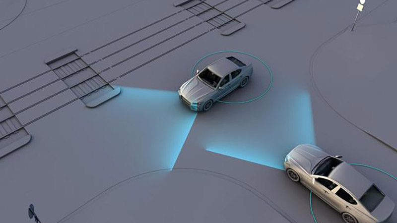
2. Accurate Distance Measurements
LiDAR provides precise distance measurements to objects and surfaces in the environment. This accuracy is important for determining the vehicle’s position relative to obstacles, road features, and other vehicles.
Accurate distance measurements allow the autonomous system to make informed decisions about path planning and navigation. For example, knowing the exact distance to a roadside object helps the vehicle maintain a safe distance and avoid collisions.
3. Real-Time Environmental Updates
LiDAR continuously scans the environment and provides real-time updates on changes and movements. This capability is essential for adapting to dynamic driving conditions and ensuring that the vehicle’s navigation and path planning algorithms remain up-to-date.
Real-time environmental updates allow the vehicle to respond to changes such as moving objects, construction zones, or road closures. This adaptability is crucial for maintaining safe and efficient navigation.
Enhancing Path Planning with LiDAR
1. Route Optimization
LiDAR’s detailed environmental mapping supports route optimization by providing information about road conditions, obstacles, and traffic. The autonomous system can use this data to calculate the most efficient and safest route to the destination.
For example, LiDAR data can help identify the optimal path around obstacles, avoid congested areas, and select routes with favorable road conditions. This optimization contributes to smoother and more efficient navigation.
2. Maneuvering and Navigation in Complex Scenarios
Navigating complex scenarios, such as intersections, roundabouts, and narrow streets, requires precise understanding and planning. LiDAR’s high-resolution mapping allows the vehicle to accurately interpret road layouts and plan appropriate maneuvers.
LiDAR data helps the vehicle recognize lane markings, traffic signals, and other road features, enabling it to navigate through intersections, execute turns, and make lane changes safely. This capability is particularly important for urban driving and handling challenging environments.
3. Dynamic Path Adjustments
As the vehicle moves, it must continuously adjust its path based on new information and changing conditions. LiDAR’s real-time scanning and data processing enable the vehicle to make dynamic adjustments to its path as needed.
For instance, if LiDAR detects an unexpected obstacle or a change in road conditions, the autonomous system can modify the planned route or maneuver to avoid potential hazards. This dynamic adjustment capability ensures that the vehicle can respond effectively to real-time changes.
Integration with Other Navigation Technologies
1. Sensor Fusion
LiDAR is often used in conjunction with other sensors, such as cameras and radar, to create a comprehensive navigation system. Sensor fusion combines data from multiple sources to enhance the vehicle’s perception and understanding of the environment.
By integrating LiDAR data with visual and radar information, the autonomous system can achieve a more accurate and reliable representation of the surroundings. This fusion improves object detection, obstacle avoidance, and overall navigation performance.
2. Advanced Algorithms and Machine Learning
Advanced algorithms and machine learning techniques are employed to process and analyze LiDAR data for navigation and path planning. These algorithms can interpret complex environmental information, make real-time decisions, and optimize routes based on various factors.
Machine learning models can be trained to recognize patterns and predict outcomes, further enhancing the vehicle’s ability to navigate and plan paths effectively. This continuous improvement in algorithms contributes to the overall performance and safety of autonomous driving systems.
Challenges and Considerations
1. Data Processing and Computational Requirements
Processing the large volumes of data generated by LiDAR and integrating it with other sensor inputs requires significant computational power. High-performance hardware and efficient algorithms are needed to ensure real-time processing and decision-making.
2. Cost and Accessibility
The cost of LiDAR technology can be a barrier to widespread adoption, especially for consumer vehicles. Efforts to reduce the cost of LiDAR systems and make them more accessible are ongoing and will play a role in the broader implementation of autonomous driving technology.
3. Environmental Adaptability
LiDAR must perform effectively in various environmental conditions, such as changing weather and lighting. Ensuring that LiDAR systems can adapt to different scenarios and maintain performance is crucial for reliable navigation and path planning.
Conclusion
LiDAR technology plays a vital role in enhancing autonomous vehicle navigation and path planning by providing high-resolution 3D mapping, accurate distance measurements, and real-time environmental updates. Its contribution to route optimization, maneuvering, and dynamic adjustments is essential for safe and efficient driving. Integrating LiDAR with other navigation technologies and addressing challenges will continue to improve the performance and reliability of autonomous vehicles, paving the way for advanced and effective navigation systems.


