LiDAR (Light Detection and Ranging) technology is increasingly becoming a critical tool in urban planning, offering detailed and accurate data that helps shape smarter, more efficient cities. By providing high-resolution 3D maps and models, LiDAR enables city planners, architects, and engineers to make informed decisions about urban development, infrastructure, and public services. This article explores how LiDAR is transforming urban planning and the benefits it brings to creating more intelligent and well-managed cities.
Detailed Urban Mapping and Visualization
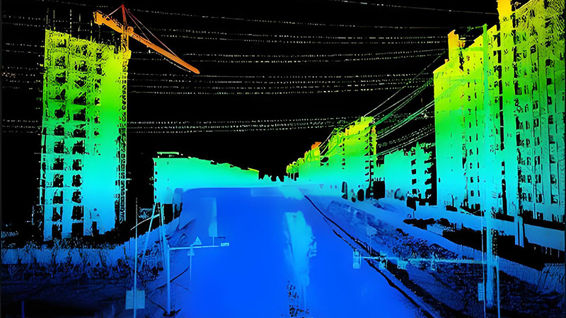
One of the primary applications of LiDAR in urban planning is creating detailed 3D maps of cityscapes. These maps provide an accurate representation of buildings, streets, and other urban features, allowing planners to visualize and analyze the layout of existing infrastructure.
LiDAR technology captures the height, shape, and spatial arrangement of structures, offering valuable insights into the urban environment. For example, planners can use LiDAR data to model new developments, assess the impact on existing buildings, and optimize land use. Detailed urban mapping also aids in designing pedestrian pathways, transportation systems, and green spaces.
Enhancing Infrastructure Planning and Management
LiDAR data is crucial for planning and managing urban infrastructure, including roads, bridges, and utilities. By providing precise measurements of the terrain and existing infrastructure, LiDAR helps engineers design and optimize infrastructure projects.
For instance, LiDAR can be used to analyze road networks, assess the need for upgrades or expansions, and plan efficient traffic management systems. It also aids in mapping utility lines, such as water and sewer systems, to ensure that new developments do not interfere with existing infrastructure. This improves the efficiency of infrastructure planning and reduces the risk of costly errors.
Supporting Sustainable Urban Development
Sustainable urban development is a key goal for modern cities, and LiDAR technology supports this by providing data that helps minimize environmental impact. By analyzing land use, vegetation cover, and topography, LiDAR helps planners make informed decisions that promote sustainability.
For example, LiDAR data can be used to identify areas suitable for green spaces, assess the impact of new developments on natural habitats, and plan for effective stormwater management. This information helps in creating urban environments that balance growth with environmental conservation and quality of life.
Improving Disaster Management and Resilience
Urban areas are vulnerable to various natural disasters, such as floods, earthquakes, and hurricanes. LiDAR technology plays a vital role in disaster management and enhancing urban resilience by providing detailed data on terrain and infrastructure.
LiDAR can be used to create floodplain maps, assess the risk of flooding, and design effective drainage systems. In earthquake-prone areas, LiDAR data helps evaluate the stability of buildings and infrastructure, identify vulnerable areas, and plan for emergency response. This information is crucial for developing disaster preparedness and recovery strategies.
Enhancing Transportation and Mobility
Transportation planning is a critical aspect of urban development, and LiDAR technology contributes by providing accurate data on road networks, traffic patterns, and transportation infrastructure.
LiDAR can be used to analyze traffic flow, identify congestion hotspots, and plan for improvements in public transportation systems. Detailed 3D models of roadways and intersections help in designing efficient traffic management solutions and optimizing routes for public transit. This leads to more effective transportation systems and improved mobility within the city.
Facilitating Smart City Initiatives
The concept of smart cities involves using technology to improve urban living through data-driven decision-making and automation. LiDAR technology supports smart city initiatives by providing real-time data and insights that enhance various aspects of urban life.
For example, LiDAR data can be integrated with other technologies, such as sensors and IoT devices, to monitor environmental conditions, track public transportation, and manage energy consumption. This integration allows for more responsive and adaptive urban management, leading to smarter and more efficient city operations.
Future Trends and Innovations
The future of LiDAR in urban planning is promising, with ongoing advancements driving new applications and capabilities. Innovations include the development of more advanced LiDAR sensors, improved data processing techniques, and integration with emerging technologies such as artificial intelligence and machine learning.
For example, the use of drone-based LiDAR systems allows for more flexible and cost-effective data collection, especially in large or complex urban areas. Integration with AI algorithms will enhance the ability to analyze and interpret LiDAR data, providing deeper insights and more accurate predictions for urban planning.
Conclusion
LiDAR technology is transforming urban planning by providing detailed, high-resolution data that enhances infrastructure planning, supports sustainable development, and improves disaster management. From creating accurate 3D maps and optimizing transportation systems to facilitating smart city initiatives, LiDAR offers significant benefits for shaping smarter, more efficient cities. As technology continues to evolve, LiDAR will play an increasingly important role in advancing urban planning and enhancing the quality of life in urban environments.


