LiDAR (Light Detection and Ranging) technology has become an essential tool in urban planning, helping to create smarter, more efficient cities. By providing accurate, high-resolution 3D maps of urban landscapes, LiDAR enables city planners to design infrastructure, manage resources, and improve the overall quality of life for residents. In this article, we’ll explore how LiDAR is revolutionizing urban planning and what it means for the future of city development.
High-Precision Mapping for City Design
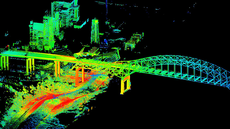
One of the most significant advantages of LiDAR in urban planning is its ability to generate precise 3D models of cities. These models include everything from buildings and roads to trees and public spaces. LiDAR’s high accuracy allows planners to visualize current infrastructure and understand the spatial relationships between different elements of the urban environment.
With this data, urban planners can assess existing conditions and plan new developments with a clear understanding of the impact on traffic flow, green spaces, and pedestrian pathways. LiDAR data helps planners make informed decisions about zoning, construction projects, and infrastructure upgrades, ensuring that cities grow in a sustainable and organized manner.
Monitoring and Managing Infrastructure
Cities rely on complex infrastructure systems for transportation, utilities, and public services. Over time, these systems can deteriorate, leading to costly repairs and inefficiencies. LiDAR is increasingly being used to monitor the condition of infrastructure, such as roads, bridges, and buildings, allowing city officials to identify problem areas and prioritize maintenance.
For example, LiDAR can detect cracks or deformations in road surfaces and bridges, helping engineers identify structural weaknesses before they become dangerous. This proactive approach not only saves money but also improves safety for residents and commuters. Additionally, LiDAR can be used to map underground utilities, such as pipelines and electrical cables, preventing accidental damage during construction projects.
Optimizing Traffic and Public Transportation
Efficient transportation systems are a critical aspect of urban life, and LiDAR plays a key role in optimizing traffic management. By providing real-time data on traffic flow, vehicle density, and pedestrian movement, LiDAR helps city planners design smarter traffic patterns, reduce congestion, and improve public transportation systems.
LiDAR is also used in the development of autonomous transportation networks, including self-driving buses and shuttles. These vehicles rely on LiDAR to navigate city streets safely, ensuring they avoid obstacles and follow designated routes. As autonomous transportation becomes more widespread, LiDAR will be central to the integration of these systems into urban environments.
Disaster Preparedness and Environmental Monitoring
Cities are increasingly vulnerable to natural disasters such as floods, earthquakes, and wildfires. LiDAR is being used to create detailed risk assessments by mapping floodplains, fault lines, and fire-prone areas. This data helps urban planners design cities that are more resilient to natural disasters by identifying high-risk areas and ensuring that infrastructure is built to withstand extreme conditions.
Additionally, LiDAR is valuable for environmental monitoring, particularly in tracking air quality, vegetation cover, and urban heat islands. Cities can use this data to implement green initiatives, such as planting more trees or creating more parks, to improve air quality and reduce heat buildup in densely populated areas.
Smart City Applications
LiDAR’s role in urban planning extends to the development of smart cities. In a smart city, data from LiDAR sensors is integrated with other technologies, such as Internet of Things (IoT) devices, to create a connected urban environment. This data can be used to optimize energy consumption, manage waste collection, and enhance public safety.
For instance, LiDAR can be used to monitor pedestrian traffic in busy areas and adjust lighting or traffic signals based on real-time data. It can also improve security by detecting suspicious activity in public spaces, providing an added layer of safety for residents.
Conclusion
LiDAR is transforming the way cities are planned and managed. Its ability to generate detailed 3D maps, monitor infrastructure, and optimize traffic systems makes it an invaluable tool for urban planners. As cities continue to grow and face new challenges, LiDAR will play a crucial role in building smarter, more resilient urban environments that enhance the quality of life for all residents.


