LiDAR technology is playing an increasingly important role in environmental monitoring by providing precise data to track changes in ecosystems, landscapes, and natural resources. From mapping forests to assessing coastal erosion, LiDAR’s ability to capture detailed 3D data enables scientists and environmentalists to monitor environmental conditions, detect changes, and develop strategies for conservation and resource management.
Forest Monitoring and Management
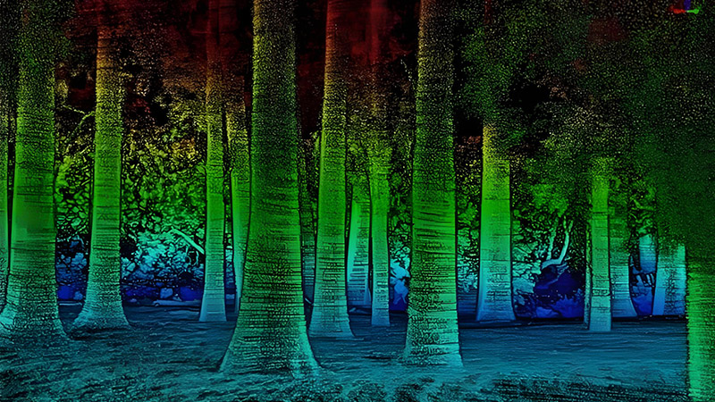
LiDAR is particularly useful in forest management, where it is used to map tree canopies, estimate biomass, and assess the health of ecosystems. By using airborne LiDAR scanners, researchers can generate highly accurate 3D maps of forested areas, showing the structure and density of trees. This helps in measuring the growth rates of forests, detecting signs of disease, and calculating carbon storage—an essential factor in combating climate change.
One of the most important applications of LiDAR in forestry is monitoring deforestation. By comparing LiDAR scans over time, researchers can detect areas where trees have been removed, either due to logging or natural events like wildfires. These insights are critical for developing strategies to protect vulnerable forests and for reforestation efforts.
Coastal Erosion and Flood Risk Assessment
Coastal areas are particularly vulnerable to erosion, rising sea levels, and extreme weather events. LiDAR is used to monitor shorelines and coastal landscapes, providing valuable data on how these areas are changing over time. High-resolution LiDAR scans allow scientists to create detailed models of coastal zones, helping to predict areas at risk of erosion or flooding.
This information is essential for developing mitigation strategies, such as building seawalls, restoring wetlands, or implementing early warning systems for communities at risk of flooding. With LiDAR’s ability to capture real-time data, environmental agencies can monitor these vulnerable areas and respond to potential disasters more effectively.
Water Resources and Hydrology
LiDAR also plays a critical role in the management of water resources. By mapping river systems, floodplains, and watersheds, LiDAR helps hydrologists and water resource managers understand how water flows through the landscape. This data is crucial for flood risk management, irrigation planning, and ensuring that water resources are used sustainably.
In agriculture, LiDAR is used to create topographic maps that inform water distribution strategies, ensuring that crops receive the right amount of water while preventing soil erosion. Additionally, LiDAR is used to monitor the health of wetlands and water bodies, which are vital ecosystems for biodiversity and water purification.
Environmental Conservation and Wildlife Habitat Mapping
LiDAR is an invaluable tool for mapping and monitoring wildlife habitats. By providing detailed 3D data on landscapes, it helps conservationists understand the spatial structure of habitats, allowing them to identify areas critical for biodiversity. For example, LiDAR can be used to map the canopy cover in tropical rainforests, where many species depend on the upper layers of the forest for survival.
LiDAR is also used in tracking changes in habitats due to human activities such as deforestation or urban expansion. Conservationists can use this data to identify areas where ecosystems are under threat and take action to protect endangered species or restore habitats. This information is particularly important in regions where rapid land-use changes are occurring, such as in the Amazon rainforest or coastal mangroves.
Climate Change and Carbon Sequestration
One of the most significant environmental challenges today is climate change, and LiDAR plays a critical role in efforts to monitor and mitigate its effects. By measuring the amount of carbon stored in forests, LiDAR helps scientists estimate how much carbon is being sequestered by natural ecosystems. This information is vital for understanding the global carbon cycle and developing strategies to reduce carbon emissions.
LiDAR can also help track the impact of climate change on landscapes, such as glacier retreat, changes in vegetation patterns, and shifts in coastline due to rising sea levels. These insights are essential for developing long-term climate adaptation strategies.
Conclusion
LiDAR’s precision and versatility make it an indispensable tool in environmental monitoring. Whether it’s tracking deforestation, assessing flood risks, or mapping wildlife habitats, LiDAR provides the detailed data needed to protect ecosystems and manage natural resources effectively. As environmental challenges such as climate change and habitat loss continue to intensify, LiDAR will play an increasingly critical role in preserving the planet’s natural systems and ensuring a sustainable future.


